.png)
My favorite trekking area in Israel has to be the Eilat Mountains Region. This is where I first learned how to hike and trek. I dived deep into the knowledge of Geology, the corals of the red sea, identifying fossils in limestone and minerals that make up Granite, and learned about the huge diversity that the Acacia trees enable in this extreme isolated desert.
In this region it rains between 0 and 50 m”m each year, and still the mountains’ riverbeds are teeming with vegetation and colour. The contrast between the blue sea, in the middle of this extreme desert that’s tainted with red, black, purple, pink, white mountains, is mesmerizing and unforgettable.

This trek is located in the north part of the Eilat Mountains (about a twenty-minute drive from Eilat, the city). The trek begins at the Red Canyon – a canyon composed of red and purple sandstone walls. You’ll hike between these walls down into the Shani stream, where you’ll meet limestone riverbanks while walking on a sandstone riverbed. The trail will lead you in the Raham Wadi and you’ll enjoy some shade under palm trees. The first day ends inside the wide Raham Wadi at the official campsite. The next day takes you on an adventure in the Etek Canyon, a narrow limestone crevice that fills up with deep water pools after flashfloods. From the Etek pools, the trail takes you up these amazing cliffs and boulders to the Seifim flatland and from there down to the upper Shani riverbed back to the beginning of the trek.

Trek Summary
Days: 2
Kilometres: 37
Best Season: Autumn to Spring
Difficulty Level: Difficult
Geographical Area in Israel: The Eilat Mountains
The important details you need to know in order to hike this trek:
Trail description: day 2
Detailed map link

Seasons for Trekking
This trek is suitable (weather wise) from October to April. You should be aware that the Eilat Mountains can get really hot, even during the winter time. The best possible months to be trekking here is January to March. Be aware that flash floods can occur in this area during this season so make sure to check the weather report before you head out. Do not attempt to hike this trek during heavy rain. Check out seasons in Israel for more information.
Transportation
This trek is accessible by public transportation, there is an official bus stop on the road leading to the beginning of the trek. You should be aware that there is not bus station here (although the official bus transportation website shows this bus stop as an option), and the bus driver might be surprised that you want to get off at this station. Make sure you’re specific and that he understands where you want to get off. You can take this bus from Be’er Sheva or from Eilat. For the starting point write down Eilat/Be’er Sheva and the destination should be “Har Uziya”, “Red Canyon”. For the bus schedule and bus information here.
You can take the same bus on your way back, but since there is not actual bus station the bus may not actually stop for you. In this case you can call any taxi from Eilat to take you to the city.
For more on trekking in Israel using public transportation here.
By car – you can park your car at the beginning of the trek, at the Red Canyon camping site. There is a large, free parking area and it is fairly safe to leave it here for the duration of the trek.
If public transportation is not an option for you, and neither is a car, you can take a taxi to and from Eilat to the beginning and end of the trek.

Water Supply
You may find some pools along the trek in different river beds, but it is not advisable in Israel to drink from springs and pools. This is due to the fact that people swim in them, they may be contaminated by different animals and sometimes by factories that are far from the eye but can contaminate the springs and pools. When you trek in the desert, first of all use your water wisely. You should be carrying at least 4.5 litres per person per full day of trekking (6 if the weather is hot). Keep in mind that you need water for the campsites, for cooking and drinking during the night. That can be pretty heavy if you’re carrying water for more than two days.
On this trek you’ll need to carry at least 9 litres. If that’s too heavy for you, you can arrange water caches at your campsite. This can either be done by yourself via a four by four vehicle and a few days ahead of your trek or by someone with a jeep who can do this for you for a fee (It depends on where the cache is, but it can cost around 100 nis per person per night). If you’re planning on cooking by campfire, you should also arrange some fire wood, since burning any local vegetation is forbidden.
If, like me, you don’t own or rent a four by four vehicle, I recommend paying someone to do your water caches, they can also bring you fire wood at an extra fee. Water caches should cost around 70 nis per night per person, fire wood is an extra 70 nis per night. There are a few people who do this in the desert area. I recommend contacting Yanir Bamidbar. You can check out Yanir's website for more info.
Food
You’ll have to carry your food with you for the two days. You can buy everything you need in Be’er Sheva or Eilat.
Precautions and Dangers
1. Flash floods - The desert area in Israel is prone to flash floods. The lack of vegetation in the desert and the type of soil make it hard for water to seep down. When there is enough rain in the desert, it flows on top of the surfaces to the lowest places- river beds. Most of the riverbeds in the desert are dry all year round, except for a few days when it rains. The rivers then come to life, and it is very dangerous to be hiking in a riverbed during a flash flood. In some areas it can be raining even a few kilometres upriver from where you are and the flash flood will come out of nowhere, splashing down the riverbed and taking everything it can with it. The tricky part about flash foods is that the riverbed does not flood gradually, it comes at you at lightning speed. Precautions for flash floods:
a. Check the weather in the destinated hiking area before you leave.
b. Do not attempt to hike if there is a rainy weather report.
c. If you do find yourself in the desert during heavy rain, make sure to get out of any riverbed near you, climb to the highest, safest point you can get to and contact someone for help. If there are flash floods around you, it can keep flowing for hours and even days, contact someone to get you out of there safely.
2. Heat stroke- It can get hot during the day in the desert, even in freezing January, especially in the Eilat mountains. The days are hot and the nights are cold. Make sure to always wear a sun hat, take long breaks in the shade and refreshen yourself in pools and springs along the way.
3. Dehydration- The desert can get really hot, and it is usually very dry. Even during the winter season, remember to drink a lot. Do not take less than 4.5 litres of water with you per day per person. You should wear sunglasses, a hat and a long-sleeved shirt. If you’re feeling dizzy, nauseous or/and have a headache, you’re probably dehydrated. Find a shade to rest and drink your water slowly and gradually.
4. Animals- There aren’t any big dangerous animals in the desert. Beware of snakes and scorpions, especially during the spring time and around your campsite. In the morning shake your boots before you put them on and beware when you pick up rocks.
7. Nature reserves- The whole trek is located inside the amazing nature reserve of the Eilat Mountains. Make sure you know the basic guidelines for trekking in nature reserves.
If you find yourself in an emergency situation, you can call for help. Call 100 for the police and they can connect you with the regional rescue team. You can also call 101 for medical assistance. The direct number for the rescue team in the Eilat region is 050-6276442.

Trail Description
Day 1
If you’re coming by car, park you car at the Red Canyon campsite and look for green trail.
If you’re coming by bus, get off at the Har Uziya Red Canyon junction, you’ll see a red marked trail that follows a dirt road. Follow the red trail mark for 1 kilometre, until you meet the green trail which will take you to the starting point of the trek. Check out trail marks in Israel for more information.
The green trail will at first lead yo through a wide dry riverbed, with some acacia trees and sandstone gravel underneath your feet. After almost a kilometre the green trail will take you deep into the crevice of the Red Canyon (if you’d rather walk above the red canyon you can take the black trail that bypasses the canyon). Inside the canyon you’ll climb down some ladders and enjoy high walls coloured by red sandstone formations.


The canyon is about 500 metres, at the end of it you’ll see a sign leading you back to the campsite. Just go around the sign and keep following the riverbed and the green marked trail. You’re now in Wadi Shani, a beautiful river (dry most days of the year) that’s right on the geological crossing between limestone and sandstone. You’ll meet a black trail mark from the south, keep following the green trail. At this point you’ll see a very short canyon of limestone. From here on out the river, for the next few kilometres, will be littered with huge boulders that fell from the walls imposing on the river. You’ll be passing between and above these boulders and the trail may take some time.

Once the river opens up a bit, you’ll find a junction with a red trail mark that you can take either south or north. I’d recommend taking the southern trail, heading to the Raham river pools (that are empty and shallow most of the year) and the Raham palm trees, right above the pools. When you’re on the red trail heading south, you’ll enjoy a spectacular view of the mountains surrounding you but make sure to also check the ground every once and a while – you’re sure to find some crazy fossils on this trail!


The red trail will take you above the Raham riverbed, until you meet the palm trees. At this point you’ll meet the Israel Nation Trail (and also a black trail), and you’ll head back north but this time inside the Raham river.

After a kilometre and a half on the INT and the black trail, the river will open up and you’ll meet the green trail (fit for 4 by 4 vehicles). From here on out follow the green vehicle trail that will take you through the wide Raham riverbed. On this trail you’ll find a lot of huge acacia trees (that offer great shade), desert flora and open up your eyes for ibexe and gazelles!

After five kilometres, you’ll arrive at the official campsite, called the Raham-Etek campsite. You’ll be camping here for the night.
Day 2
The next day will take you up the Etek river. From the campsite find the blue trail mark heading back west (a 4 by 4 vehicle trail). Follow this trail into the Etek valley which will be really wide for the first five kilometres. It will resemble the Raham valley from the day before, a lot of great acacia trees, fossils and local desert flora and fauna.

After about 5.5 kilometres, look for the green trail heading north and follow it. The trail junction is not very clear, make sure not to miss it. You’ll be venturing into the Etek crevice.

The river will start getting more and more narrow. Right before the crevice there is a red trail mark that will take you to a bypass of the crevice from the west side. In the Etek river, look for the crazy Bulbus fossils, they look like this:

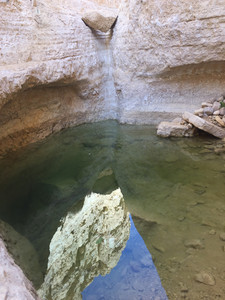
If you follow the green trail into the crevice, you’ll meet a lot of ladders taking you up into the water pools. If you’re lucky, and you’re here after a flashflood you’ll find some big pools! Since the crevice is shaded most of the day, the pools here can hold water for a few months after flashfloods. Some of the pools may be very deep, and you have to go into the pools in order to pass the crevice. If they’re not too deep, you can try holding your pack above your head to cross the pools (like we did). If the water is too deep, you can carry an inflatable water tube with you and stack your pack on top of the inflated tube and carry it across the pool. If none of these are an option, you can leave your packs at the beginning of the crevice, enjoy the pools and bypass the crevice from above on the red and blue trail with your packs.


Once you’re out of the Etek crevice you’ll meet the blue trail again. Follow it for a kilometre until you meet the black trail heading south, along a small scale riverbed to a pass. From the pass you’ll be descending through a pretty steep trail (with some great views) into a riverbed. After the descent, you’ll find a green trail heading either northwest or southeast.

Take the trail heading northwest and upriver. After a few hundred metres, you’ll find the Etek water pit, a small clear water pool here only after heavy rain. After the water pit, you’ll get to a huge waterfall. You can follow the transparent trail mark up to the base of the (dry most of the year) waterfall. The green trail will take you up to an ascent that bypasses the waterfall. The trail will then take you along the river, and after about a kilometre the trail starts ascending to the south of the river. Make sure not to miss the ascent, it’ll be right after a few acacia trees inside the river, to your left (south) side.
You have about a 250 metre ascent now, a fairly easy way up, with some incredible views and great fossils to ease your climb.

At the end of your ascent the green trail will take you to the red trail heading south (you’ll find a great acacia tree at the junction). Take the red trail heading south. The red trail can be monotonous for the first few kilometres. After 3-4 kilometres you’ll get to the Seifim flatland, which is a pretty remarkable view and you’ll enjoy some great wildflowers if you’re here after January.

After 6 kilometres you’ll meet a lone great acacia tree and from here you have two options. If you have two hours before sunset I’d recommend heading down the green trail (that’s marked at the site but not on the map, I marked it for you on the map). The green trail will take you into Seifim river, a beautiful riverbed filled with giant boulders (which is why it takes time).

After a kilometre you’ll meet the black trail mark which you can follow into the upper Shani river, and then take the short green trail m ark heading back to the Red Canyon campsite. If you don’t have the time, from the lone acacia tree just keep following the red marked trail for another two easy kilometres which will take you straight back to your car. If you need to get to route 12 keep walking along the red marked trail for another kilometre (from here you can try taking the bus, calling a taxi or hitchhiking).
Side note- if you’re taking a taxi, you can shorten this last part. Once the green trail meets the red trail, don’t follow the red trail south. Just follow the green trail heading farther west until it meets route 12. Send the taxi your specific location because he won’t know where you’re at, and there is no specific junction here that he can write down.
Some last great photos that emphasize the colourfulness of this trek:


Hope you enjoyed the trek, I would love to hear your thoughts about it! Contact me here! or comment below.
*Disclaimer*
It is the responsibility of the users of this website to be prepared for all possible conditions while trekking in Israel. Beware that conditions of trails may change day to day and season to season. All users of this website and its information assume full responsibility for their actions and judgments while trekking. The owner and authors of this site disclaims all liability including that of accident, loss, injury, or any other damage that may be sustained by anyone using the information contained on this website.
Comments